News
Council and SRF hold meeting
Scott Wagar
04/16/2013
The development of Bottineau’s Comprehensive Plan continues after February’s public input meeting. Since the meeting, SRF Consulting Group, Inc. examined the future vision posters and the sketch maps that participants completed.
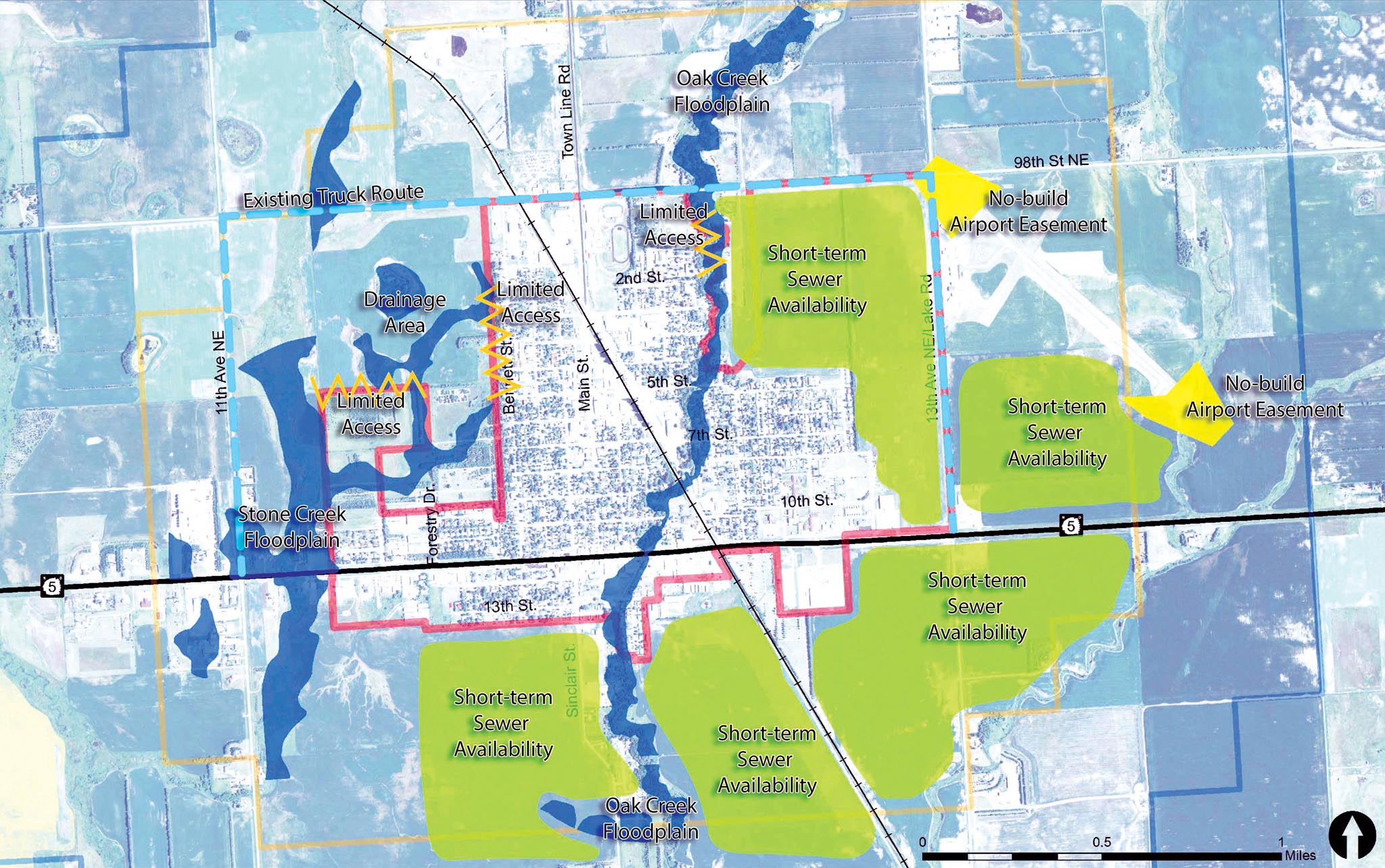
Wold Engineering contributed to a map of opportunities and constraints to future city growth. This map identified areas which are less costly to serve with sanitary sewer services and areas which are more challenging. The map also identified floodplain, drainage, and road access limitations.
Two alternative land use plans for future growth within city limits and the one mile extraterritorial area were prepared based on input from the public input meeting and known opportunities and constraints to growth.
At a special City Council meeting Tuesday night, land use planners with SRF Consulting and an engineer with Wold Engineering met with council members to discuss constraints to future development and the to draft alternative land use plans. Beginning with the downtown, the council reviewed the future land use proposals for the entire city and the surrounding area. Local knowledge of the city and the surrounding area was provided by the council members, leading to several changes to the draft plans presented. As a result of the council’s input, SRF Consulting and Wold Engineering will refine the land use proposals into a draft preferred land use plan during the coming weeks.
The land use plan is intended to guide city growth for approximately a 30 year time frame. However, more frequent updates to the plan are advised, particularly if the city experiences an accelerated rate of growth. Some common themes from the public input meeting have been incorporated into the draft land use plans. They include:
- special focus on the vitality of the downtown
- limiting and focusing growth into targeted areas
- alternative locations for future park and recreation sites
- a location for a future RV park
- areas for industrial growth near the railroad
- new commercial opportunity areas
Concern was raised by the council regarding the need for the Comprehensive Plan to have a special focus on recreation, including routes for a future trail alignment through future growth areas.
Concern was also expressed regarding recent increases in truck traffic and the need to provide a plan that minimizes the impact of truck traffic on the community. The project team will work to address these concerns in the Comprehensive Plan document.
The next public meeting for the Comprehensive Plan will be early this summer. At the meeting, the draft Comprehensive Plan document including the draft land use plan will be presented. At that time, additional input from the community will be needed.
Writer’s Note: The red boundary marker on the SRF’s map on the front page map shows the current city limits. The gold marker recognizes the one-half mile extraterritorial boundary, which under North Dakota Century Code, the city has sole zoning jurisdiction in that area. The term, “short-term sewer “availability” (the green markings) means these areas can access (upgrade) the sewer system without a major cost in the next five to 10 years. These areas are also ideal for gravity flow and no need or limit need for lift stations.