News
Making a mark in time within the local area
Scott Wagar
08/07/2012
When crossing through the Turtle Mountains trekkers can find a variety of interesting items. From Norwegian’s caves, mooring stones, Roman hilts and prohibition stills there is an adventure of objects to discover.
Outside of discovering bits and pieces of history in the local mountains, one can also find benchmarks and boundary monuments which grant the local people in the area with important information about the area they live in.
BOUNDARY MARKER:
When it comes to boundary monuments, these types of markers are throughout the Turtle Mountains because of the 49th Parallel, or what is referred to as the Queen’s Highway, which runs directly through the mountain plateau and identifies the locations of the United States and Canada.
According to John Bluemle of the North Dakota Geological Survey Department in his writing, North Dakota Boundaries, the boundary monuments in the area date back to 1814 during the Treaty of Ghent and completed by the 1818 Treaty of Peace, which established a boundary line west from the Lake of the Woods along the 49th parallel.
“The International Boundary was first surveyed and marked during the years 1872 - 1875 by surveyors of a United States and British boundary commission. From the Red River of the North to a point on the boundary two miles west of the 99th Meridian (northwest of Sarles, Cavalier County, North Dakota), the boundary was originally marked with cast-iron posts five feet high, set one mile apart along the line. From that point to the western boundary of North Dakota, the line was originally marked either with stone cairns or earth mounds, 10 to 16 feet in diameter, 5 to 8 feet high, erected about three miles apart along the line,” Bluemle stated. “Under a treaty between the United States and Great Britain, signed in Washington, April 11, 1908, the boundary was re-surveyed and re-marked in 1910 and 1911. Along the section of the line to the 99th Meridian, the original cast-iron posts were reset in concrete bases and elsewhere, the stone cairns and earth mounds were replaced with new cast-iron posts, set in concrete bases, as well as placing similar intermediate monuments on the line between the original marks that had been set at three-mile intervals.”
Each monument is inscribed with the word “Canada” on the north side of the monument and “United States” on the south side of the marker. The west side of the boundary monument states “October 20, 1818” while the east side hold the words “Convention of 1818.”
In the eastern part of the Turtle Mountains, is an iron boundary monument which stands eight feet high, has an eight inch square bottom, four inch square top and holds a pyramid shape cap which is simply called TFO137.
The National Geodetic Survey (NGS) department conducts surveys on the monuments to check the conditions of each of the markers. According to the NGS datasheet, TFO137 is the 708th marker on the 49th parallel. In 1988, the NGS discovered the monument was out of plumb five centimeters to the east and four centimeters to south. It was later re-plumbed in 1989 and corrected.
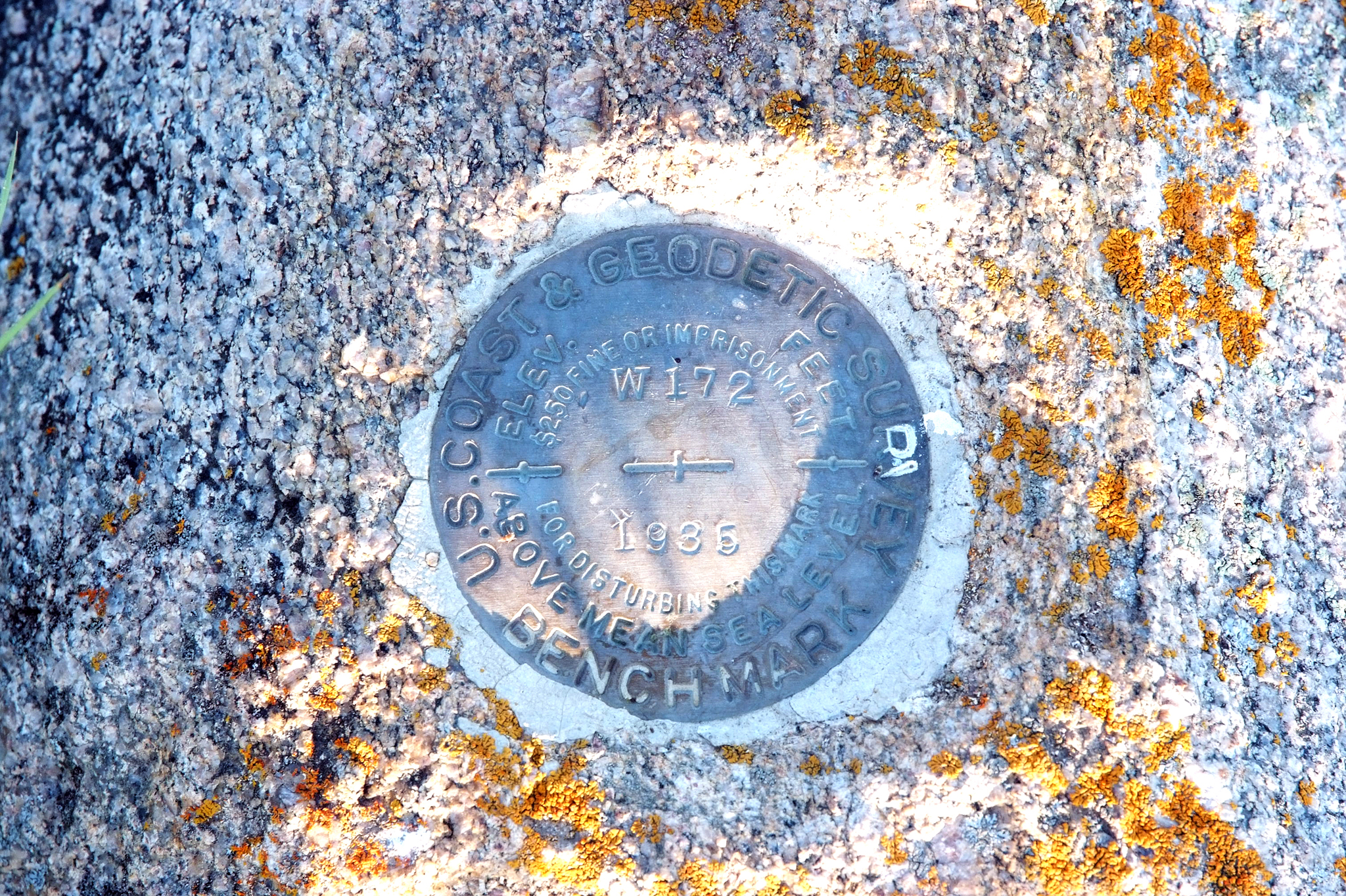
BENCHMARKS:
Within the Turtle Mountains, there are benchmarks which can be found on fixed and steady surfaces like boulders or post markers, and which hold a metal disk with precise information about the markers’ locations, elevations and dates when the markers were placed in specific locations.
Just a short distance from TFO137, is benchmark TFO136, which can be found on top of a granite boulder in the eastern part of the Turtle Mountains in Rolette County and is located 365 feet south of the U.S./Canadian border.
Benchmark TFO136 holds a number of interesting markings on its round disk, some of which includes “W172,” “1935,” and a number of odd looking lines or symbols that go through the center of the marker.
For the average person, the markings on the disk makes no sense at all, but for surveyors, engineers or map makers the markings make perfect sense and are utilized for referencing in their line of work. The W172 tells of the designation of the boulder and 1935 is the year the disk was placed on the rock. The odd looking symbols are actually crossed lines that mark the elevation of that location above the mean sea level, which at this location in the Turtle Mountains is 2,252.97 feet above the mean sea level.
When it comes to hiking throughout the Turtle Mountains, there is always something interesting to find, which includes bench and monument markers that grant individuals a glance back into history as to how the land was surveyed starting back in the early 1900s.